
Introduction
Landscape design is not just planting — it is terrain intelligence.
At Draftitecture, we translate conceptual landscape intent into technically precise documentation that aligns with topography, drainage logic, and site execution realities.
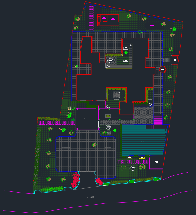
This project showcases complete landscape CAD detailing for a plantation-inspired residential site with sloping road access and integrated hardscape zones.
Project Overview
This landscape documentation package included:
- Site boundary drafting
- Contour-based topography coordination
- Planting layout with species tagging
- Pathway and natural stone paving detailing
- Swimming pool landscape integration
- Existing vegetation preservation zones
- Road interface level control
The objective was to produce a construction-ready landscape drawing that contractors could execute without ambiguity.
1. Topography & Contour Coordination
The site features a natural slope toward the road edge.
We documented:
- Level transitions from road to entry
- Retained plantation edges
- Controlled gradient pathways
- Natural drainage direction
- Stepped landscape zones
Contour-sensitive detailing ensures:
✔ Proper water runoff
✔ No soil erosion
✔ Balanced cut-and-fill control
✔ Seamless road interface
2. Planting Plan Documentation
Each plant species was clearly tagged and positioned for long-term growth logic and visual layering.
🌳 Tree & Plantation Zones
- Chikku (Sapodilla)
- Rambutan
- Custard Apple
- Mangosteen
- Cashew
- Red Palm
These fruit-bearing and tropical species were organized along the boundary to create a layered green buffer.
🌿 Shrubs & Accent Plants
- Heliconia psittacorum
- Pencil Bamboo
- Calathea lutea
- Bougainvillea
Accent planting was coordinated near pathway curves, entry points, and edge conditions to enhance visual movement.
3. Hardscape & Softscape Integration
The layout integrates:
- Natural stone paved zones
- Grid-based driveway pattern
- Curved pathway transitions
- Poolside landscape coordination
- Entry planting beds
Hardscape edges were aligned precisely with softscape zones to prevent installation overlap.
4. Existing Vegetation Preservation
An existing fruit tree was retained and documented as:
- Protected root zone
- Non-disturbance area
- Adjusted pathway curvature
This ensures ecological sensitivity while maintaining design intent.
Drafting Standards Applied
For this project, we implemented:
- Layer-based softscape/hardscape segregation
- Botanical tagging clarity
- Boundary offset referencing
- Topographic reference lines
- Clean dimension hierarchy
- Print-ready annotation scaling
The result: a landscape drawing that bridges aesthetics and execution.
Why Landscape Detailing Matters
Without technical documentation:
- Plants are misplaced
- Levels are misinterpreted
- Drainage fails
- Hardscape clashes with roots
- Soil erosion occurs
Professional landscape detailing ensures:
✔ Proper growth planning
✔ Accurate excavation control
✔ Seamless contractor coordination
✔ Reduced site rework
✔ Long-term landscape stability
Project Summary
| Feature | Scope |
|---|---|
| Service Type | Landscape CAD Detailing |
| Project Type | Residential Sloped Site |
| Focus | Plantation Zoning & Contour Alignment |
| Key Elements | Fruit Trees, Pathways, Natural Stone |
| Tools Used | AutoCAD |
"A successful landscape is built with soil — but planned with precision."
At Draftitecture, we document landscapes with the same rigor as buildings — ensuring nature and structure work together seamlessly.
Need landscape documentation support?
Draftitecture provides backend CAD and BIM landscape detailing for architects and designers who want execution clarity without expanding their in-house team.